Winter Weather: A Donut Hole Around the Radar
- Bryan Mroczka
- Oct 21, 2022
- 6 min read
Updated: Jan 8, 2024
The forecast for the western suburbs of Chicago calls for snow to commence in the next several hours. Curious as to how long until the first flakes fly, you give the local radar a quick look. The image on the radar screen is confusing, as you live just west of Chicago and see snow portrayed by the radar display in all directions around you, yet you are quite sure it has not snowed at your house. This radar display looks like a donut, with you high and dry in the middle!
How can this be? One might begin to wonder if there is some kind of force field around the radar, keeping the snow from reaching you, and ruining kids hopes for a day off school. However, what we see on the radar screen is not the work of a magical force field, or secret military technology, but rather a simple consequence of a mis-match of displayable dimensions.
A typical radar display / scan is actually composed of 3-dimensional data,
X-> East to West
Y-> South to North,
Z-> Vertically
but is usually displayed in only 2-dimensions (X and Y), as shown in Figure 1. Removing the Z-component from the display, results in a visual misrepresentation of the data.

In the animation (Figure 2) we begin with radar data shown in the typical 2-D display format (looking down from directly above) and turn the data on its side to show the the full 3-D representation. It certainly looks quite a bit different at the end of the animation, with a "curved" shape to the 3-D data.
Let's take a closer look at the final animation frame in Figure 3, where annotations have been added.
From the perspective of Figure 3, it is as if we are standing on the ground, looking northward toward the radar site. The white ball in the middle of the image represents the radar dome (using my limited artistic skills). The 3-D coordinate system is denoted with the red lines, X along the east->west direction, Y along the south-north direction, and Z pointing upwards (vertically) from ground level. The yellow lines indicate the height (Z coordinate) of the radar beam above the ground, moving outward from the radar site.
From this image we can see that a single 2-D radar image actually shows us data that exists at various altitudes above the ground. In close proximity to the radar, the data is at a low altitude, closer to ground level, but travelling further away from the radar, the data represents data that the radar sees at higher and higher altitudes above the ground.

One might naturally ask why the radar is even sampling data at different heights above ground at different distances from the radar? There are two reasons that this change in height occurs, and we will do a deep-dive into both within the paragraphs below.
First, radar beams are usually tilted slightly upward from the horizontal when leaving the radar dome. When you see the term tilt 0.5 or 0.5 degree slice associated with a radar product, that number is telling you the degree of tilt from the horizontal that the beam is angled leaving the radar. For a National Weather Service radar site, such as we are examining here, these tilts usually run between 0.5 degrees on the lowest scan, up to 19.0 degrees at the top scan. A beam with any amount of tilt upward, will gain altitude as it travels away from the radar.
The range of tilts is known as a Volume Coverage Pattern (VCP), and different VCPs are used by meteorologists depending on the type of weather being examined. To learn more about VCPs, check out this informative website from NWS Jetstream.
For the purposes of this blog, we have so far been examining the 0.5 degree tilt only, and will continue this for the rest of the discussion. The 0.5 degree tilt (lowest beam angle) is the most common radar data displayed by public radar sites and media outlets, as it represents the closest possible representation of what is occurring at ground level.

The second factor relates to the curvature of the Earth's surface. We live on a sphere, and although it is usually imperceptible to us, the Earth is curving away from any specific location in all directions. The same is true for the radar beam. The Earth constantly curves away, increasing the beams height above the ground with distance from the radar, as seen in figure 4.
Now that you have a good idea of how the radar beam actually samples to creates a 3-D dataset, let's use that knowledge to examine why we can get the radar "force field" or "donut" signature in the 2-D display.

In Figure 5 we start our scenario at noon CST, with the same snow event moving into the Chicago area. The red dots in the right 2-D radar image are co-located with the vertical-dashed red lines in the left image. This left image maintains the ground-level perspective looking north, as from Figure 3. The radar dome is located in the middle of the left image, and the green lines represent the paths of the beam when the radar dish is arbitrarily pointed due east and due west. The beam will rotate at this trajectory to complete the full 360 degree scan seen on the right. Finally, the middle color-bar indicates the dryness or saturation of the air in the vertical from ground level to the base of the clouds.
Snow events obviously occur within a cold atmosphere, but another characteristic of the cold is often a dry airmass. At noon CST, snow is falling from the clouds aloft, but quickly evaporating as it falls and encounters the drier air below. At this time, the snow is completely evaporating before falling to the altitude of the radar beam located inside the red-dashed lines. Therefore, inside this radius around the radar, the beam is sampling only clear air. Outside of this radius the beam has reached an altitude where the flakes still exist, and the signal detected at the radar from those flakes paints a particular color on the right-side map.
A general picture is now coming together concerning the genesis of the "donut". In the paragraphs below, we'll examine how this radar signature evolves over time.

Let's move forward one hour (Figure 6 to 1:00 PM CST). The snow is now reaching a lower altitude before completely evaporating. As snowflakes evaporate they transfer their moisture to the surrounding air, increasing the saturation of that air, and slowing the evaporation of snowflakes following behind. Through this process, snow makes greater and greater progress toward the ground over time before fully evaporating. The red dots, and corresponding vertical red lines in Figure 6 have moved in toward the radar site, with the beam encountering snowflakes at a lower altitude compared to one hour prior. The radius of the "donut" signature in the 2-D display begins to shrink.

We now move forward another hour to 2:00 PM CST (Figure 7). The processes occurring in Figure 6 continue, and the moistening/saturating through evaporation has progressed even further down toward the surface. Snow is now able to descend to an altitude only 1,000 feet above the ground before fully evaporating. The red dots/lines move even closer in to the radar, making the "donut" radius & overall area smaller and smaller with time.

Finally, moving forward one final hour to 3:00 PM CST (Figure 8), the moist/saturated air now extends down all the way to the surface, allowing snowflakes to survive the entire fall from cloud-base to your house on the ground. The beam is now finally sampling snowflakes immediately upon leaving the radar, and the donut hole vanishes from the display. The entire process from Noon CST until 3PM CST is animated for additional clarity in Figure 9.


Combining the discussed issues of displaying 3-D data on a 2-D display, with the commonality of dry air at the beginning of snowfall events, radar "donut holes" are a semi-common occurrence during the winter months.
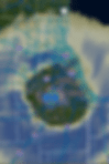
Figure 10 shows another recent example from the NWS Detroit (KDET) radar during February of 2023. I happened to be located within this reflectivity void region to the south of the radar site. Snow was indeed not falling at this time, but would commence within the next hour, as the final bit of dry air in the lower levels of the atmosphere was scoured out by evaporating snowflakes.

A final recent example comes from the NWS Taunton, MA radar (KBOX), showing the formation of the donut hole at the onset of a winter weather event in southern New England on March 3rd, 2023.
Thank you for reading and I hope you both enjoyed the article and learned a bit about radar meteorology. Be on the lookout for additional radar lessons in future posts from the meteorologists at Streamline Weather Consulting, LLC.